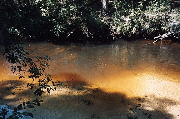
Unnamed Econfina Creek-bed Spring*
Washington County
Summary of Features
- Scale - 2nd magnitude (est.)
- Scenery - excellent
- How Pristine? - pristine
- Swimming - poor
- Protection - excellent
- Crowds - none
- Access - very good, boat only
- Facilities - none, good at park ½ mile upriver
- Safety - very good
- Scuba - no
- Cost - free

Directions
Quick Directions
About 1/3 mile downstream of Walsingham Park in Washington County in the bed of Econfina Creek.
Full Directions
From the intersection of State Road 20 and U.S. 231 north of Panama City, drive west on SR20 about 7 miles to bridge over Econfina Creek. Continue another 1/3 mile, then turn right onto Strickland Road. Drive 2.6 miles to stop sign at T-junction. Turn left at stop sign onto what becomes Porter Park Road. Continue 2.3 miles, then turn right onto Hampshire Road. Continue 1.2 miles, then turn right at the sign for Walsingham Bridge. Continue another 1.55 miles to one-lane plank Walsingham Bridge over Econfina Creek. There is a primitive launch at the SE edge of the bridge, or carry on another ¼ mile to Walsingham Park, which has a better boat launch. The possible spring site is in the riverbed, just over a half mile below the Walsingham Bridge and shortly past where power wires cross the river.
Spring Description
This possible spring site is on a sharp river bend. A submerged limestone shelf extends about 10 feet across the river from the west bank in the center of the bend (which is sharply to the left as one goes downstream). A large submerged tree trunk is a few feet upriver of the limestone shelf and lies parallel to it, athwart the river. There are prominent boils raised 1-2 inches above the common river surface and covering an area perhaps 10 feet across. The water is clear to a depth of about 4 feet, and yellow-brown. Water appears to flow from the bottom of the limestone shelf across the river toward the east bank where there is large sandy area.
The authors were searching for a spring at this approximate location based on a line in Carter & Pearce stating the presence of “another spring that boils up in the river another half mile [below Walsingham Spring]” (1985, p. 56). JF attempted to free-dive the site, but the powerful current, dark water, and sand particles prevented identification of a flow point at the base of the limestone shelf. The water appeared to be about 8 feet deep at the base of the shelf. The river is about 30 feet across at this point, and the general depth is about 4 feet.
As with nearby Walsingham Spring, this site is characterized as a possible spring. A vent was not seen, and turns in river can create surface disturbances that look like spring boils.
Use/Access
- Land around the river is protected by the Northwest Florida Water Management District.
- There is no utilization of the site.
Personal Impressions
The site is attractive and lively, with strong river and possible spring flow combining on a sharp bend of the river. The sandbank on the east side provides a good spot for beaching, picnicking, resting, and contemplating whether there is a spring flowing strongly 20 feet away. The authors reached this spot in the morning when temperatures were cool,and JF did not want to paddle in cold wet clothing after diving into thepossible spring. So, he stripped and explored the spring au naturale, which ruined his paddling companion's experience at the site!
Nearby Springs
- Walsingham Spring
- Glowing Spring
- Blue Springs Group (9)
- Below-Blue SpringRun
- Gainer Springs Group
- Twin-run Grotto Springs Group
- McCormick SpringsGroup
- Williford Spring
- Williford Run Springs
- Pitt Spring
- Sylvian (orSullivan) Spring
- Ponce de Leon Springs
- Vortex Spring
- Cypress Spring
- Morrison Spring
Other Nearby Natural Features
- Pitt Spring Recreation Area
- St. Andrews State Recreation Area
- Falling Waters State Recreation Area
