Blue Springs
Levy County
Summary of Features
- Scale -2nd magnitude
- Scenery -good-very good
- How Pristine? -retaining wall around spring, land cleared on two sides, dive platform and beach, small building and parking area nearby
- Swimming -excellent, outstanding snorkeling
- Protection -very good
- Crowds -heavy on warm weekends
- Access -excellent
- Facilities -good
- Safety -good-very good
- Scuba -yes
- Cost -$0.50 per person

Directions
From Chiefland, take Alternate U.S. 27 east. Cross the Waccasassa River after 9.4 miles and the Little Waccasassa River after about 11 miles. Continue around a bend and U.S. 27 merges with Highway 339. After about 1 more mile, turn right onto Levy County Road 339A at sign for Blue Springs and proceed 2.2 miles to the spring. From Bronson, 339A is 2.4 miles west on Alt. U.S. 27 after the last traffic light in town (Thrasher Street).
For maps, latitude/longitude data, driving directions, satellite imagery, and topographic representations as well as weather conditions at this spring, go to Greg Johnson's informative "Florida Springs Database" web site at the following address: http://www.ThisWaytothe.Net/springs/floridasprings.htm#Florida
Spring Description
The spring forms a large circular pool about 150 feet across. There is a retaining wall/sidewalk around the eastern 2/3 of the pool, an artificial beach on the north side, woods on the south side, and the spring run to the west. A diving/jumping platform extends over the deepest part of the basin from the NNE. The bottom below the platform and extending into the middle of the spring slopes down to a depth of about 18 feet. Water is very clear and an intense blue.
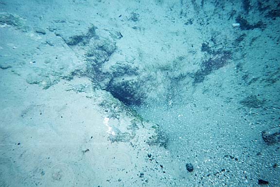
Much of the bottom is sandy, and the are numerous small and large sand boils. Some flow points "blow" small particles of wood and shells. A section of the bottom is covered with a layer of mostly liquefied black detritus about a foot thick. Water flowing from beneath this layer makes the black material churn and boil on the bottom. A few bream swim here and there over the boils. More sand boils are in the lower part of the pool nearer the run and the wading beach. Bream and bass were more plentiful in this area. The spring run is thick with hyacinth and shaded with a canopy of trees. The run feeds the Waccasassa River, which flows through the Waccasassa Bay State Preserve to the Gulf of Mexico. Land to the west and south of the spring is thick hardwood and floodplain forest.
Use/Access
The spring is the site of a county park that is open from Memorial Day to Labor Day. The park offers swimming, picnicking, restrooms, concessions, playground equipment, and grills. There is a shallow area at the beach for young children.
Springiana
- Note the signs and restrictions at the park. One sign says, "No Alcohol – Coolers will be checked." Another forbids drugs and also pets; teenagers are warned not to use the covered picnic tables. They ignored the warning when RB was there.
- Intrigued by the black liquid layer on the bottom the pool, JF thrust his hand into it to pull up shells, rocks, soaked wood, and a large alligator tooth. A State of Florida scientist said it was from a gator about 10 feet long and could have been preserved in the spring for thousands of years.
Personal Impressions
The spring seems incongruous placed in this rural spot, as if it were dropped from the sky. The roiling black bottom is a must-see for snorkelers—there are as many boils in this spring as in any spring the authors have seen, and they have not observed the black layer in any other spring.
Nearby Springs
- Manatee Spring
- Fanning and Little Fanning Springs
- Hart Springs
- Otter Springs
- Wekiva Springs
- Copper Spring
- Little Copper Spring
- Sun Spring
- McCrabb Spring
Other Nearby Natural Features
- Manatee Springs State Park
- Waccasassa Bay State Preserve
- Goethe State Forest
- Rainbow Springs State Park
- Fanning Springs State Recreation Area
- Paynes Prairie State Preserve


