Chipola Unnamed Limestone Boulders Springs
Jackson County
Summary of Features
- Scale--3rd or 4th magnitude, est.
- Scenery--Fine
- How Pristine?--Undisturbed, just below farm fields, near Interstate 10
- Swimming--No
- Protection--unknown
- Crowds--None
- Access--Very good, by boat only
- Facilities--None
- Safety--Very good
- Scuba--No
- Cost--Free

Directions
Accessible via boat. From Intersection of Interstate 10 and State Road 71, go south about ½ mile and turn right/west onto State Road 280 (look for sign for boat launch). Drive about 1 mile to boat launch on SW side of the road/bridge. Put in and go upstream about 0.3 miles. The spring enters the river on the east side, adjacent to several large flat boulders in the river near the mouth of the short spring run. GPS coordinates: N30.43.287; W85.11.904
Spring Description
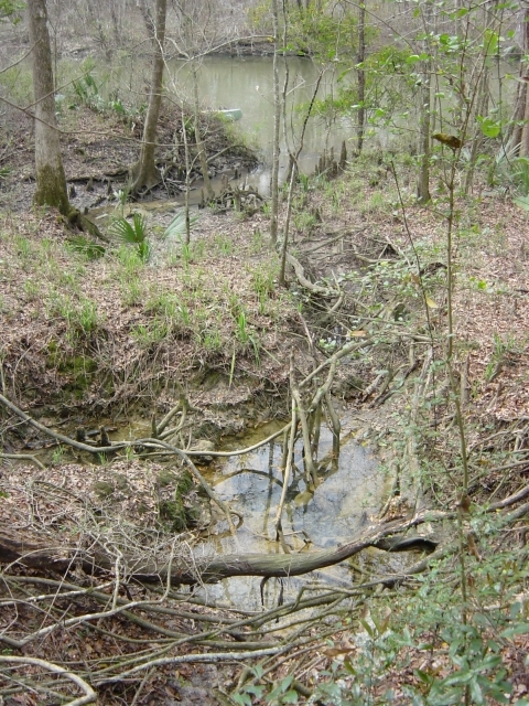
The spring flows from various points, depending on levels of rain and the Chipola River. The primary flow point is from the bottom of a depression/collapse located about 60 feet east of the river. This pit, which is criss-crossed with tree roots, has the approximate dimensions of 12 feet across and 6 feet deep (the water in the hole/pit is 1-2 feetdeep). Water flows from the bottom through several small openings or sand boils. The water is clear and odorless, and there were minnows in the depression/pit. Water from these openings flows/seeps back underground and reappears or flows outward again at other openings 15-35 feet away/to the west. In early March 2004, water was visible flowing either upward from the ground (i.e., springflow) or downward (i.e., beneath the surface) at three other points, including two smaller holes or depressions.
In early March 2004, this second flow point was 20 feet away in a much smaller pit (just a few feet across and about two feet deep). This flow did not escape the small depression, but was recaptured and flowed underground again and reappeared at 2-3 other small flow points about 15 feet away. The 3rd set of vents create slight flows and raised sand boils and form a short run (15 feet long, 5 feet wide, and about 8 inches deep) that opens directly into the Chipola River. The spring water is clear and odorless. When visited again under somewhat drier conditions, the secondary flowpoints were dry, and all the water from the main depression appeared to be flowing from one spot about 35 feet to the west and 20 feet from the river. This flow was from a limestone opening under a rock and created a small creek that flowed into the river amid a series of boulders that line the eastern bank.
Use/Access
There is no apparent use of this spring, which is very near I-10 and has a small line of trees separating it from upland farm fields.
Personal Impressions
A beautiful little spring complex, this site is well worth a visit and the short upriver paddle against the moderately strong current of the Chipola River. JF and RB nearly lost their canoe at this spot. They did not tie the canoe, and just happened to look back to see it floating downriver. JF had to race through the tangle of brush to a small rocky outcrop 50 feet downriver and leap into the water after it!
Nearby Springs
- Baltzell (or Bosel or Bozel) Springs group
- Blue Hole Spring
- Sandbag Spring
- Unamed Grotto/Wastewater Spring
- Unnamed Alcove Spring
- Unnamed Chipola Riverbank Springs
- Dykes Spring
- Unnamed Spring Cascade
- Delightful Grotto Spring and Cascade
- Unnamed Rock Overhang Seep
- Unnamed 2-Tree/3-Trailer Seep
- Unnamed Possible Chipola Spring Runs (5)
- Unnamed Chipola West Bank Seeps
- Possible Spring run Near Highway 280 Bridge
- Merrit’s Mill Pond Springs (Jackson Blue, Shangri-La, Twin Caves, Indian Washtub, Gator)
- Spring Lake Springs (Black, Double, Gadsen [or Gadsden], Millpond, Springboard,Coffin)
Other xxxxxxxxxxxxxxx Features
- Florida Caverns State Park
- Three Rivers State Park
- Falling Water State Park
- Torreya State Park
- Apalachicola Bluffs and Ravines Preserve


