Lake Jessup Spring
Seminole County
Summary of Features
- Scale -4th magnitude (estimated)
- Scenery - good
- How Pristine? - linked to drainage ditch, near homes, land partially cleared
- Swimming - no
- Protection - unknown
- Crowds - none
- Access - water only
- Facilities - none
- Safety - very good
- Scuba - no
- Cost - free

Directions
From the intersection of Central Florida Greeneway (Highway 417) and Highway 434 in Seminole County, drive east on 434 for 1.7 miles. Turn right (north) onto Tuskawilla Road. Go 0.58 miles to sharp left and turn left on to Orange Avenue. Orange Avenue becomes dirt. Go 0.3 miles to spring on the right.
Spring Description
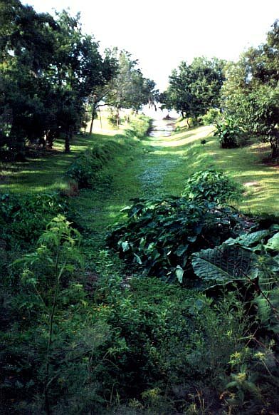
Lake Jessup Spring lies in a manmade boat slip that has been extended as a drain/runoff ditch. According to Rosenau et al., the spring was created by the excavation of the boat slip in 1952, and continued to flow after the spring hole was filled with logs, clay, and sand (1977, p. 339). The excavation was extended approximately 300 feet to create a municipal drain/runoff ditch into Lake Jessup.
The flow point is about 90 feet from Lake Jessup. On date of visit in June 2001, water could be seen starting at this point and continuing to the lake. The flow appeared very small, consistent with the 4th magnitude flow (about 1 cubic foot per second) described in Rosenau et al. Land around the spring is mostly cleared residential landscape, with large hardwoods and palms and decorative plants along the ditch.
*The declaration of this site as Lake Jessup Spring is not a positive identification. It is based on directions published in 1977, latitude and longitude records and matching (but JF did not have a GPS to be precise), and visual comparison of the site with a photograph taken in 1972 from the opposite direction (i.e., from Lake Jessup). JF could have the wrong site.
Use/Access
- No apparent use.
- The site is on private property and is fenced and posted. The photographs were taken from the road at a distance of approximately 300 feet.
Nearby Springs
- Wekiwa Springs
- Rock Springs
- Elder Spring
- Clifton Springs
- Palm Spring
- Sanlando Spring
- Miami Spring
- Starbuck Spring
- Gemini Springs
- Seminole Spring
- Green Spring
- Health Spring
- Volusia Blue Spring
Other Nearby Natural Features
- Blue Springs State Park
- Hontoon Island State Park
- Wekiwa Springs State Park
- Ocala National Forest
- Tosohatchee State Reserve